AUSTRALIA
In Australia there are well-kown National Surfing Reserves. With the emblematic case of Bells Beach, and the subsequent mainly symbolic recognitions, the National Surfing Reserves becamen, at least in the state of New South Wales, legally and officially recognized by the State. This is because they were designated by the Department of Lands as Crown Reserves under the Crown Lands Act 1989.
Furthermore, the values of surfing have been recognized in other official documents, such as the City of Gold COast's Surf Management Plan, which, while not officially recognized, gives importance to the place and the decisions made about it.
AUSTRALIA
1/
GENERAL STANDARDS FOR THE PROTECTION OF SURF BREAKS
In Australia, surf breaks have been protected in two ways. Firstly, with the landmark recognition of Bells Beach (state of Victoria) as a surf reserve and, subsequently, with the establishment of a national surfing reserves program. Secondly, Australia has key regulations, such as the Coastal Protection and Management Act 1995, as well as fairly advanced processes related to marine spatial planning, where surf breaks are considered for their importance for recreation and tourism.
1.1. THE CASE OF BELLS BEACH
In Torquay, in 1973, the first formal governmental recognition of a surfing reserve was given to Bells Beach. The reserve encompasses both onshore and offshore extending 400 meters offshore areas from the lowest tide. Inland, the reserve is bounded by a sculpture, a mural and sandstone engraved with the words "Respect the Ocean - Spirit of Surf." It also includes infrastructure to promote public use of the surf break: a parking lot, walkways and access ramps to the shore of the beach.
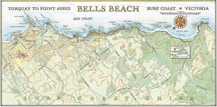
ap of the surfing points of Bells Beach, from Torquay to Point Addis. Source: Guy's Surfari Maps.
The reserve is recognized as a historic landscape of cultural significance to Australian recreational and competitive surfers. It is listed on the Victorian Heritage Register as the Bells Beach Recreational Surfing Reserve, and on the Australian National Heritage List.
The process, which culminated in this recognition, began with a request for the establishment of a management committee for Bells Beach. In 1966, during a public meeting, the first committee was elected, reporting to the Shire of Barrabool. In the following years, the committee progressed plans for the formal identification of a reserve within a field of Crown land adjacent to the coast, which had already been identified as a site for public purposes in 1880 and declared inalienable (i.e., permanently reserved from sale) in accordance with the provisions of the Land Act 1869. The committee suggested that this land be named Bells Beach Recreational Surfing Reserve and managed as such.
This led to the development of regulations applicable to the new reserve area, under the provisions of the Land Act 1958, and the appointment of the Barrabool Shire Corporation as the managing committee. Through another legislative route, the new name was assigned under the Coordination of Topographic Studies (place names) Act.
In 1993, a new round of legislative changes led to the creation of 14 coastal reserves and Victoria's coastal zone under the provisions of the Crown Lands (Reserves) Act 1978, including the Bells Beach Surfing Recreation Reserve. This Act is still in force today and focuses on the care, protection and management of the reserves, thereby delineating the roles of the reserves management committee.
Currently, the reserve is managed by the Surf Coast Shire Council with support from the Department of Sustainability and Environment, in compliance with the Crown Lands Act 1978, and comprises 48 hectares of coastal heathland, limestone cliffs, reefs, and sandy beaches adjacent to a two-kilometer stretch of coastline. The Council adopted a specific management plan for the reserve in 2004, developed under the Coastal Management Act 1995 and the Victorian Coastal Strategy 2008. In accordance with that , any use or development of the reserve requires the consent of the Department of Sustainability and Environment.
The current management framework was reviewed between 2014 and 2015, through the Bells Beach Surfing Recreation Reserve Coastal Management Plan 2015-2025. This participatory process included extensive public consultation, and was followed by an additional review, between 2019 and 2020, leading to the adoption of updates to the management plan in 2021.
The review process was also influenced by the establishment of a dedicated park management authority, by law, to protect and manage Crown coastal lands and marine waters along the Great Ocean Road. State government-driven developments were associated with the enactment of the Marine and Coastal Act of 2018, under which the Bells Beach Surfing Recreation Reserve Coastal Management Plan was approved, whose requirements were directly incorporated into the most recent plan update.
Thus, despite not having been declared a World Surfing Reserve nor being a National Surfing Reserve, Bells Beach is the first surfing reserve in history, decreed as such in 1973 by Surfing Victoria, in conjunction with local surfers and Torquay Council. The roles of the local committees are retained in these new arrangements, which have remained there since 1971. The local community is involved in the management of the reserve through the Bells Beach Committee, which includes representatives from the local community and the Wadawurrung Aboriginal Traditional Owners Corporation and Surfing Victoria.
1.2. NATIONAL SURFING RESERVES
Concern for the future of surf breaks motivated a group of Australians, led by Brad Farmer and Andy Short, with the support of the then federal Minister of Environment, Peter Garrett, and Minister of State Lands, Tony Kelly, to create a Surfing Reserves Committee in 2005. The purpose was to protect surfing areas of local and national importance by recognizing them as national surfing reserves. This designation allows an area for use by surfers as sites of historical, cultural and environmental significance in Australia. The intention of this recognition is twofold: it contributes with the long-term preservation of surf breaks, and it gives the local community a recognized voice and platform to participate in broader decision-making processes affecting the coast.
The first surfing reserve was established in Maroubra, New South Wales in 2006, although it was merely a symbolic declaration, as it did not entail any legal recognition. However, since then, in partnership with the National Surfing Reserves of Australia, the New South Wales Department of Lands began to give legal recognition to surf breaks under the Crown Lands Act 1989. Thus, they became designated by the Department of Lands as Crown reserves, and published as such in the Official Gazette, in order to recognize their historical, cultural, and environmental qualities. Thus, the relevant ministry can create reserves that establish controls on developments through processes such as environmental impact assessments and reserve management plans.
The surfing sites designated as national surfing reserves under the Crown Lands Act 1989 required a "reserve trust" system, through which, with support from the Crown Lands Office, the surfing community was provided a voice on issues related to the site and its development. A management plan was developed to address environmental issues and determine responsibilities associated with their management.
The Crown Lands Act 1989 was subsequently repealed by the Crown Lands Management Act 2016, which consolidates eight previous legislative acts and includes more stringent requirements for community involvement in the management of Crown lands. This rule does not affect prior recognition of national surfing reserves.
Under the Crown Lands Management Act 2016, Crown lands of local importance are managed by municipalities as if they were municipally-owned public lands. This feature is a significant change from the previous system, where management functions were carried out by reserve trusts. In addition, management plans must be prepared for all Crown reserves; however, relative to the number of existing reserves, few management plans have been prepared.
A place can be considered a surfing reserve according to the quality and consistency of its surf, and according to the relationship between the surf and the surfers (which must be prolonged and consistent). A national surfing reserve must meet the following three criteria, which are accompanied by examples taken from Australia:
Persistent wave quality; a surf break of national class or world class. For example, North Narrabeen or Snapper Rocks.
Site considered sacred by local or national surfers. For example, Angourie and Crescent Head.
Long-term use of the beach and wave environment by the local and national surfing community, as occurs with a lifesaving club or a board club with a significant history. For example, Maroubra or Killalea.
The process for establishing a national surfing reserve is as follows:
The local community initiates the nomination process (usually a surf club or a local surfing group).
The nomination is approved by the National Surfing Reserves Board of Directors.
A brochure is created that captures the history of surfing at that location, the histories of Aboriginal cultures associated with the area, wave conditions, reef configurations, and the more recent surfing culture of the local community.
A plaque is installed at the site.
A dedication ceremony is held in collaboration with local and state authorities.
These steps usually take a year to be completed. It is the community that decides how far the reserve extends along the beach. While the purpose of reserves is focused on developing a sense of community and identity for their management and protection, legal recognition is not yet achieved in other Australian states outside of New South Wales.
There are 21 national surfing reserves in Australia: Maroubra, Angourie, Lennox Head, Crescent Head, Cronulla, Merewether, Killalea, North Narrabeen, Margaret River, Kalbarri, Manly-Freshwater, Yallingup, Burleigh Heads, Currumbin Alley, Snapper-Kirra, Daly Head, Point Sinclair, Phillip Island, Noosa, Mid Coast, Bondi, and Cabarita.
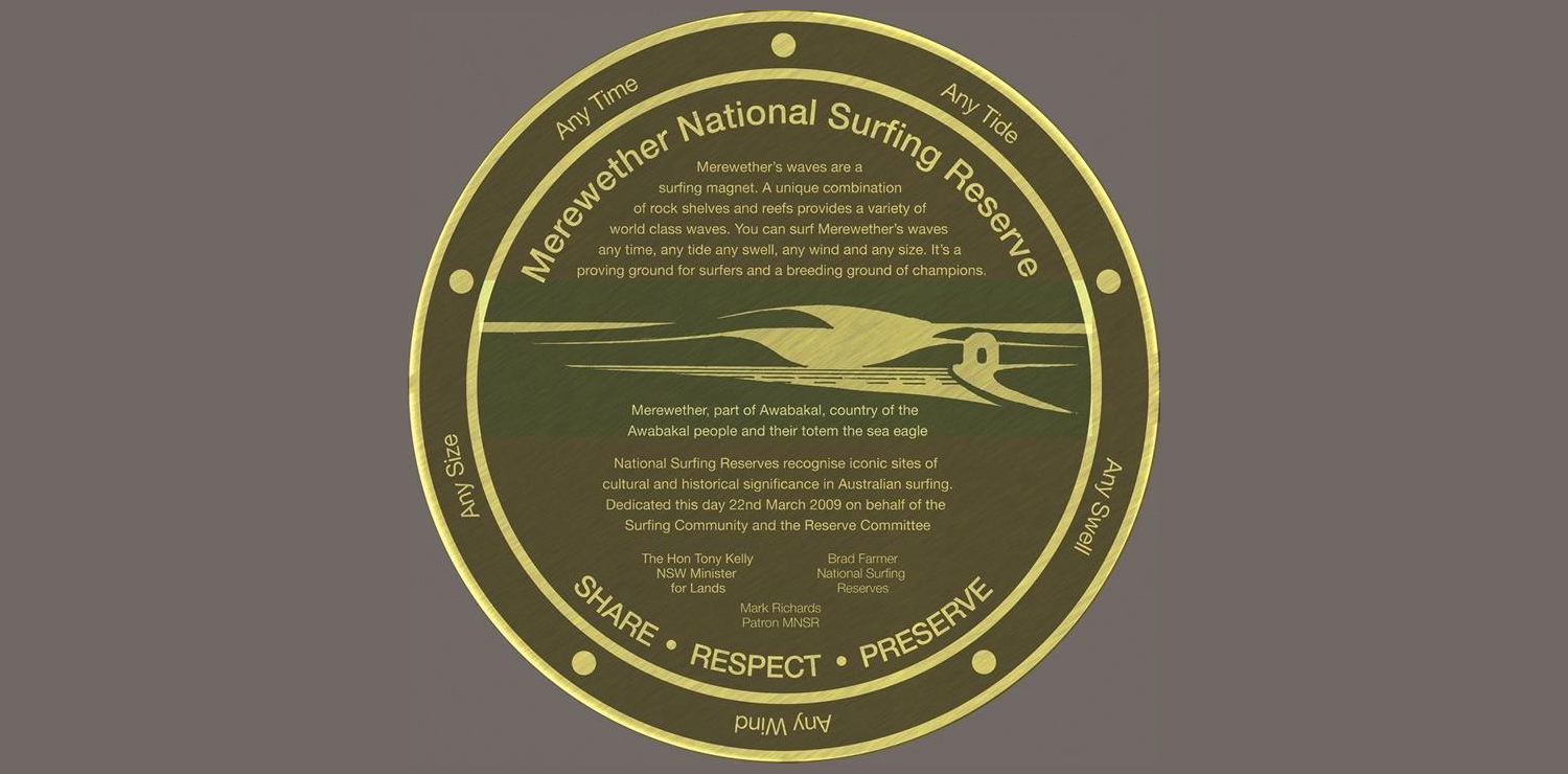
Merewether National Surfing Reserve plaque. Photo: Mauro Figueiredo (courtesy).
The Lennox National Surfing Reserve, designated on February 16, 2008, is located south of Byron Bay and north of Ballina on the NSW coast. The Lennox Reserve includes several surfing sites, from point breaks to beach breaks, and encompasses approximately 7.5 kilometers of coastal water and an area of 400 hectares. Although this reserve is recognized by the NSW Department of Lands, to date the trust board has not established a management plan to address the threats that may affect wave quality. Photo: Peter Green.
1.3. THE GOLD COAST AND ITS COASTAL MANAGEMENT PLAN
The Ocean Beach Strategy 2013-2023 aims to achieve best practice for the day-to-day and long-term management of the City of Gold Coast's beaches. One of its main objectives is to protect local infrastructure from coastal hazards.
One of the key actions of the Ocean Beach Strategy (1.3) was to develop a surf management plan that would support surfing on the Gold Coast, recognizing the importance of surfing in the culture and economy of the city. In 2013, the Gold Coast Surfrider Foundation applied to Council to develop its Surf Management Plan, which was approved in 2015 and which has recently been renewed for a further five years.
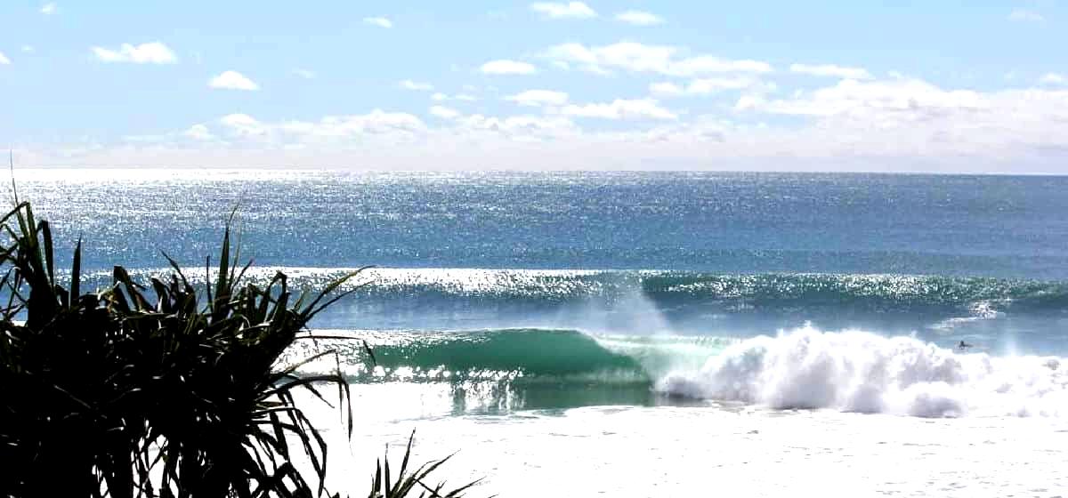
Gold Coast is one of the National Surfing Reserves (2012) and a World Surfing Reserve (WSR) by Save The Waves Coalition (2016). WSR nomination requires a management plan and the formation of a local management committee. The City Council established that the surf management plan would be the WSR management plan. Photo: Luke Sorensen.
The Gold Coast Surf Management Plan is the first to be developed as such. It recognizes that the Gold Coast beaches are a valuable natural asset contributing millions of dollars to the growth of the local economy; and also recognizes their importance to the culture of the city. In addition, it addresses the physical, social, and legislative processes related to surfing. It is integrated with the Council Plan 2022-2027 and, in line with the Ocean Beach Strategy, seeks to balance the interests of all coastal users.
Thanks to the Gold Coast Surf Management Plan, surfing modeling has been conducted, identifying the most suitable areas for coastal projects that can improve waves, such as the construction of artificial reefs.
In addition, the city must comply with the Coastal Management and Protection Act of 1995, which ensures that activities do not adversely affect coastal processes, water quality, marine ecology, fisheries, and navigational safety. This law is also considered in planning processes, regulated under the Sustainable Planning Act 2009, which requires that works in coastal or intertidal waters cannot be carried out without permits.
The city also has relevant local laws, such as Gold Coast Local Law 10 of 2014. This Act establishes bathing reserves covering the coastal zone of all Gold Coast beaches south of Seaway and extending, from mean spring low tide, to one kilometer from the coast. The only areas that have not been considered as reserves are at the mouths of Tallebudgera and Currumbin Creeks, Seaway and around the Seaway sand pumping jetty. Within the bathing reserves, lifeguards can mark "swimming areas," which must have a 400-meter offshore boundary. Lifeguards may also close a bathing reserve due to unsafe conditions, which applies to bathing, but not to surfing. Within bathing areas, to prevent accidents, zoning bans may be established for the use of surfboards or jet skis.
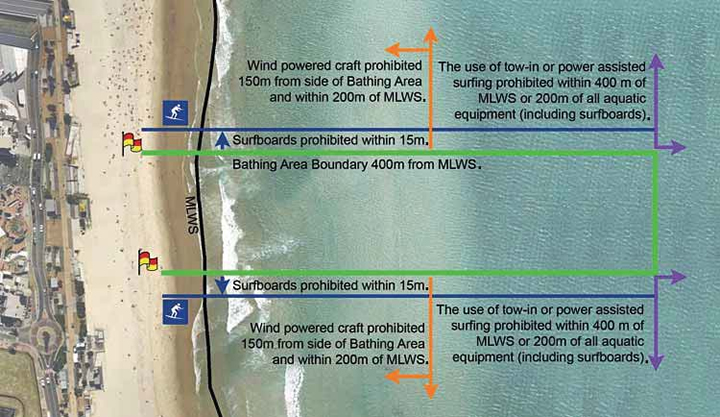
Image of the boundaries of the bathing area in accordance with the Gold Coast Local Law 10. Source: Gold Coast Surf Management Plan.
Gold Coast Local Law 9 of 2008 on parks and reserves, on the other hand, allows the city to regulate and manage activities in public places and reserves as if these were designated as public parks. If a coastal beach area is not designated as a bathing reserve under Local Law 10, Local Law 9 applies to it, and it is therefore designated as a public place. According to this law, the city regulates activities in the coastal beach zone, and commercial activities require a permit to operate in these places.
The coastal beach zone is defined in the Local Government Regulations 2012 as the land extending between the high tide mark and the low tide mark during ordinary spring tides.
Beach nourishment or replenishment has been a fundamental element in the management of the city's beaches for the past 40 years. This involves dumping or pumping of sand, carried out from a source external to the active beach system, to widen the beach and the surf zone influenced by waves. This has been recommended by the Delft Hydraulic Laboratory as an improvement for beaches affected by erosion. Beach nourishnment projects have been implemented along the coast from Main Beach to Coolangatta since the early 1970s.
The size and scale of each project has varied; however, the common purpose of each project has been to help beaches recover after long periods of erosion or following tropical cyclone impacts. Typically, the dredged sand is placed offshore , which allows wave energy, over time, to move the sand towards the shore. In some cases, the use of temporary pipelines allows the sand to be pumped and dispersed on the beach near the shore.
2/
SURF BREAKS AND PROTECTED AREAS
The law regulating protected areas in Australia is the Environment and Biodiversity Conservation Act 1999 (EPBC). This Act establishes a legal framework for the protection and conservation of the environment and biodiversity. Also, the EPBC provides the framework, at the federal level, for the identification, designation and management of protected areas in Australia, under the categories of national parks, nature reserves, marine conservation areas, marine parks, and other ecologically important areas.
At the state level, the New South Wales National Parks and Wildlife Act 1974 (NPW Act) can be used to protect various ecosystems. For example, the local community of the Killalea National Surfing Reserve promoted the establishment of a regional park under the NPW Act, which provides further protection for the reserve. Being located in New South Wales, it was subject to the Crown Land Management Act 2016; however, it was still under threat from development projects that would significantly impact the landscape. The land to be developed was located within the Crown Lands Reserve, which raised concerns that the corresponding management plan would not effectively address the protection needs of the area.
This application of the NPW Act sets an important precedent for the protection of other surf breaks in New South Wales and other states, as it may raise the standards of protection and management of surfing reserves.
A number of surf breaks enjoy indirect protection because they are located within a protected area. Some related challenges include defining criteria by which a surf break (or an existing surfing reserve) could be designated as a park or reserve under the NPW Act, and how management plans can address the protection of surfing resources in these areas.
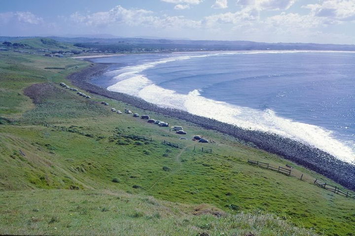
Lennox National Surfing Reserve is located partially within Cape Byron Marine Park. Photo: Peter Green.
Bells Beach Surf Reserve is located within a marine reserve where surfing is a permitted activity and is recognized as important. The reserve is regulated by the provisions of the Commonwealth Environment Protection and Biodiversity Conservation Act 1999, which sets out special protection and conservation requirements. Photo: Torquay Australian National Museum.
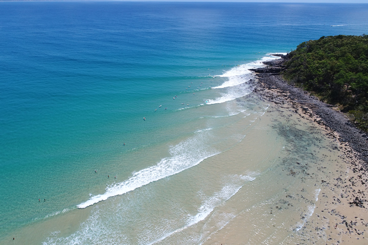
In addition to being a National Surfing Reserve and a World Surfing Reserve, Noosa is a National Park with iconic point breaks, such as Tea Tree Bay (in the image), Granite Bay and Alexandria Bay. The legislation protecting the National Park also grants protection to the surf breaks. Photo: Javier León.
Burleigh Heads National Park has surf breaks within its boundaries. Photo: Andrew McKinnon.
3/
SURF BREAKS AND THE ENVIRONMENTAL IMPACT ASSESSMENT SYSTEM
In Australia, the law that regulates environmental impact assessment is the Environment Protection and Biodiversity Conservation Act 1999 (EPBC). This Act establishes a framework for the protection and conservation of the environment, which includes the assessment of the environmental impacts of certain projects.
The EPBC requires that certain projects be assessed for their potential impact on nationally protected environmental values. Thus, projects that may have a significant impact on the environment are subject to an environmental impact assessment. This involves the submission of an Environmental Impact Statement describing the potential impacts of the project and the measures proposed to mitigate them.
The environmental impact assessment may also include public consultations and stakeholder participation in the decision-making process. The authority responsible for environmental impact assessments under the EPBC is the Department of Agriculture, Water Resources and the Environment.
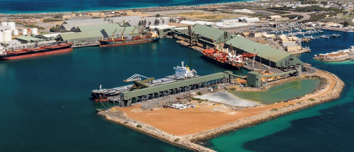
Pursuant to maintenance dredging, planned for 2021, in the Geraldton entrance channel and inner harbour, as well as the placement of dredged material offshore of Bluff Point, an environmental impact assessment was conducted on the project, in accordance with the Western Australia Environmental Protection Act 1986. The stakeholder consultation associated with the project assessment considered the impact that the project might have on the surf breaks. The conclusion was that it would have no significant impacts. Source: Environmental Impact Assessment for Geraldton Channel Maintenance Dredging Project 2021.
3.1. THE CASE OF PALM BEACH
Since 1967, there have been numerous episodes of erosion along Palm Beach on the Gold Coast. The erosion of Palm Beach threatened the beachfront infrastructure, exposed sea walls and, due to the temporary loss of the beach, jeopardized the lifestyle of locals. For example, in 2009, sections of the seawall were exposed and a viewpoint was lost due to heavy surge. Also, during the 2013 and 2016 extra-tropical cyclones, the surge reached the boundaries of many oceanfront properties in Palm Beach.
To address this problem, the city developed the Palm Beach Shoreline Project, which consisted of a beach nourishment campaign to stabilize the beach with an artificial reef. However, the project was abandoned moments before construction began, because analysis showed that surf breaks could be affected. Simulations and review of existing literature showed that the waves breaking on the reef, as well as those passing over the reef, would be significantly modified and would have a serious negative impact on the existing surfing in the area.
Although the project attempted to develop an integrated, multifunctional coastal management strategy, it was clear that public participation in the process, with inadequate preliminary consultation, was poor and insufficient. Contradictions and limited evidence regarding the hypothesis that the project would not impact the surf breaks caused beach protests that drew over 1,200 people.
At subsequent meetings, the Gold Coast City Council suggested that the services provided by the surf breaks be incorporated into state policy to ensure that the Palm Beach situation was not replicated elsewhere. The Surf Management Plan was considered for this purpose. Additionally, there was a need to use existing information to design structures that would harmonize or enhance the surf breaks while protecting the beach.
The Palm Beach artificial reef was finally built in 2019, in a strategic location towards the offshore side of the natural reef. Thus, the structure would benefit from both the 'preconditioning' of the waves offered by the natural reef and the contour of the artificial reef aligned with the surf. In developing the solution, wave, sand volume and current data were collected. Also, numerical and physical models were used to predict the performance of the artificial reef and the behavior of the waves, thus ensuring quality surfing.
In this way, the construction of the Palm Beach reef created a wave with good results, with a wave that breaks generally to the right, although if the swell has more energy, lefts also emerge. Today there is consensus that it is a surfable, consistent wave, although it requires a swell of one to two meters to work. For the community, the reef created a new surfing spot of high quality.
This case shows the importance for developers and permitting agencies to seriously consider the impact on surfing locations during coastal management.
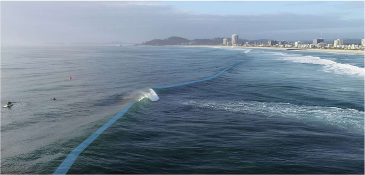
The curvatures of the wave crests, outlined in blue, occur when the artificial reef concentrates wave energy towards the crest. Photo: Surf Management Plan Five-Year Review (Annex 1). City of Gold Coast.
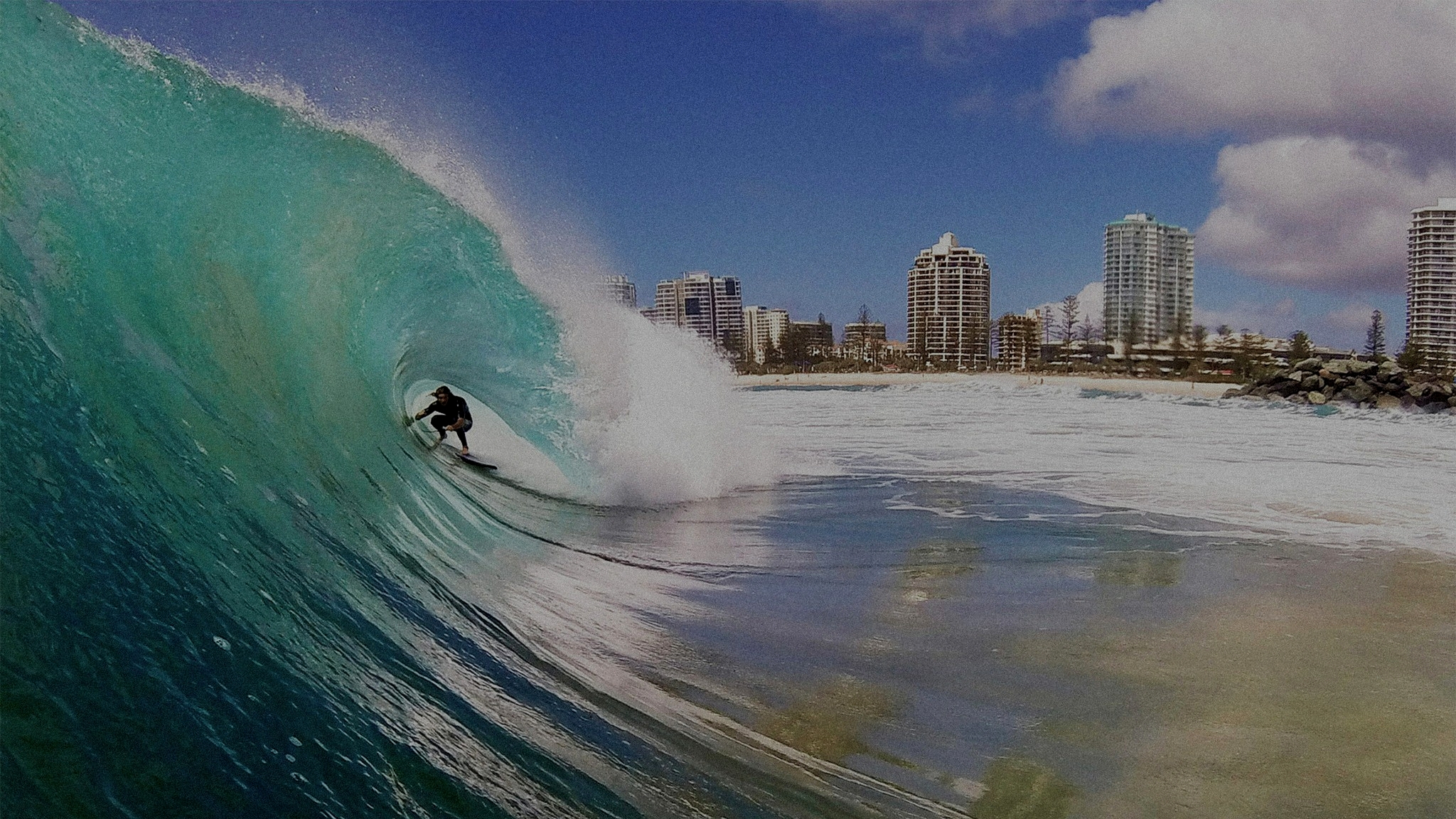
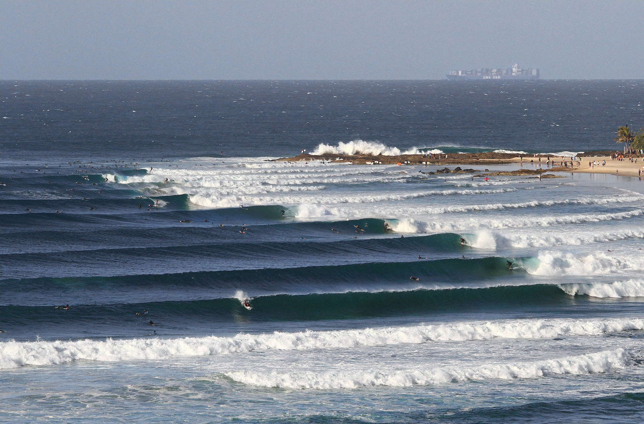
Gold Coast waves. Photo: Luke Soren.
4/
PUBLIC ACCESS
In Australia there is no private property on the coast and waters. All coastal waters (up to three nautical miles) belong to the State, are accessible to the public (unless restricted for health, safety or defense reasons) and State approval is required for any commercial activity in this area.
Thus, while there is a general principle in Australia of public access to beaches, laws regulating public access to beaches vary by specific state or territory, and may differ in terms of specific restrictions and access rights.
In some states, such as New South Wales and Victoria, the Coastal Management Act provides the legal framework for coastal management and protection, and includes public access to beaches. These laws generally protect the right of public access through easements and place restrictions on the obstruction of public access to beaches by private landowners.
In other states and territories, such as Queensland, South Australia, Western Australia and Tasmania, public access to beaches is protected by similar laws and regulations. For example, in Queensland, the Coastal Protection and Management Act provides the legal framework for coastal management and ensures public access to beaches.